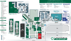
Campus Map & Parking
Below is a map of the hospital as well as driving directions for your convenience. Please click the image for a full-size map. For directions to a specific location, please visit our Locations page.

Driving Directions
Physical Address for your GPS:
Conway Regional Medical Center
2302 College Avenue
Conway, AR 72034
From the Southwest
Take Interstate 30 East to Little Rock. In Little Rock, take Interstate 430 North. Take Exit 13B toward Fort Smith to Interstate 40 West. In Conway, take Exit 127 and turn left onto Oak Street. Follow Oak Street through the downtown area to Donaghey. Turn left onto Donaghey and travel south three blocks to Ada Street. Turn right onto Ada and go two blocks.
From the Southeast
Take US 65 North from Pine Bluff to Little Rock. In Little Rock, take 143A toward Fort Smith to Interstate 40 West. In Conway, take Exit 127 and turn left onto Oak Street. Follow Oak Street through the downtown area to Donaghey. Turn left onto Donaghey and travel south three blocks to Ada Street. Turn right onto Ada and go two blocks.
From the North
Take US 65 South to Conway. Follow Highway 65B through Conway to College Avenue. Turn right onto College, then follow College to Western Avenue. Turn right onto Western in front of Conway Regional.
From the Northwest
Take Arkansas 540 South and Exit 1B to Interstate 40 East. In Conway, take Exit 127 and turn right onto Oak Street. Follow Oak Street through the downtown area to Donaghey. Turn left onto Donaghey and travel south three blocks to Ada Street. Turn right onto Ada and go two blocks.
From the Northeast
Take Interstate 40 West through Little Rock to Conway. In Conway, take Exit 127 and turn left onto Oak Street. Follow Oak Street through the downtown area to Donaghey. Turn left onto Donaghey and travel South three blocks to Ada Street. Turn right onto Ada and go two blocks.
